Tonight provides mostly clear skies. We still have a small window of viewing for the Lyrids Meteor Shower, which will wrap up this weekend! Temperatures will be a little milder tonight with a southeast wind flow instead of the northerly breeze we saw last night, with lows in the mid 50s.
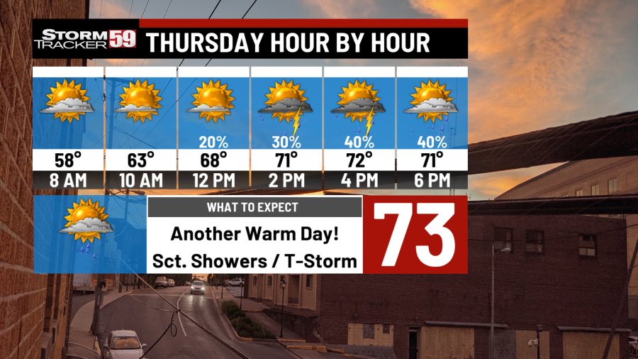
Thursday sees our stalled front that has been draped across the Virginia/North Carolina border the last couple of days begin to nudge its way back closer to the region, and that will attempt to throw a couple of more showers our way. Overall, it’s a mostly dry day with only a scattered shower or two with highs in the low 70s.
Friday provides a better risk for scattered showers and thunderstorms as that front lifts north as a warm front. One or two strong thunderstorms will be possible along this warm front, though the dynamics at play are not as strong as recent severe weather episodes. That being said, a strong storm or two amidst scattered showers cannot be ruled out, though it’s a low risk overall, with high temperatures in the mid 70s. The best chance for a storm or two will be in the middle afternoon. Showers will increase in coverage as a front approaches during the overnight hours, making for a wet stretch to begin the weekend.
Saturday begins on a wet note with a cold front crossing during the morning. Widespread showers are a good bet with clouds and an overall gross start to the day. However, the day will improve weather-wise with time and the late afternoon should be solid! It’ll be cooler with highs in the mid 60s.
Sunday features plenty of sunshine with high temperatures rebounding to near 70 degrees with plenty of sun expected.
Monday sees high pressure still in control with plenty of sunshine expected and highs in the mid 70s in what is shaping up to be another gorgeous day.
Tuesday sees a front approaching late in the day, but we should remain dry before dark. We will warm up out ahead of the front, with highs jumping up into the mid to upper 70s.
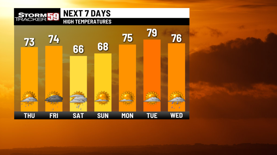
Wednesday provides more chances for scattered showers and a rumble or two with highs in the low 70s.
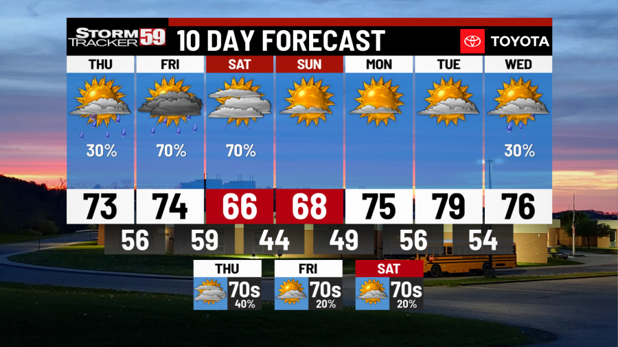
Looking ahead in your extended forecast, there will be chances for rain Thursday and Friday with a series of systems. No particular day is a washout with plenty of dry time expected. We will dry out for Saturday! Highs will be above normal in the 70s.
TONIGHT
Mostly clear. Warmer. Lows in the mid 50s.
THURSDAY
Few showers. Highs in the low 70s.
FRIDAY
Few scattered storms. Highs in the mid 70s.
SATURDAY
Early rain, late day drying. Highs in the mid 60s.
SUNDAY
Mostly sunny. Highs near 70.
MONDAY
Mostly sunny. Highs in the mid 70s.
TUESDAY
Partly sunny. Highs near 80.
WEDNESDAY
Scattered showers. Highs in the mid 70s.
THURSDAY
Showers likely. Highs in the low 70s.
FRIDAY
Rain chances continue. Highs near 70.
SATURDAY
Partly sunny. Highs in the low 70s.
Copyright 2025 Nexstar Media, Inc. All rights reserved. This material may not be published, broadcast, rewritten, or redistributed.
For the latest news, weather, sports, and streaming video, head to WVNS.