
NASA has introduced a novel method for combating wildfires with a new sensor, offering immediate information that assisted firefighting efforts in Alabama. Known as AVIRIS-3, an acronym for Airborne Visible/Infrared Imaging Spectrometer–3, this device identified a 120-acre fire on March 19 before it was even reported to authorities.
While AVIRIS-3 was onboard a King Air B200 research aircraft flying approximately three miles (five kilometers) east of Castleberry, Alabama, a researcher on board examined the data instantly and pinpointed areas where the flames were at their fiercest. This intel was subsequently transmitted through satellite internet to fire personnel and scientists on-site, enabling them to relay pictures depicting the boundaries of the conflagration directly to the smartphones used by firefighting teams in the area.
In total, the procedure from spotting the incident during the overflight to receiving an alert on portable devices lasted several minutes. Besides identifying the site and size of the blaze, the information revealed to firefighting crews its boundaries, aiding them in assessing the potential for expansion and determining where to deploy additional staff and resources.
“This demonstrates highly adaptable scientific capabilities,” remarked Robert Green, who leads the AVIRIS program as a senior researcher at NASA’s Jet Propulsion Laboratory in Southern California. He pointed out that AVIRIS-3 was used to map the burn area created close to JPL by the Eaton Fire back in January.
From an altitude of approximately 9,000 feet (3,000 meters), the AVIRIS-3 instrument was flown during multiple test missions above regions including Alabama, Mississippi, Florida, and Texas as part of NASA’s FireSense Airborne Campaign scheduled for 2025. The researchers conducted these flights primarily in late March to get ready for controlled burning tests which were carried out in the Geneva State Forest in Alabama on March 28 and later at Fort Stewart-Hunter Army Airfield located in Georgia between April 14 and 20.
During the March span, the AVIRIS-3 team mapped at least 13 wildfires and prescribed burns, as well as dozens of small hot spots (places where heat is especially intense)—all in real time.
Imagery obtained from spectroscopy instruments such as AVIRIS-3 usually requires several days or even weeks to transform into comprehensive, multi-layered image files utilized for scientific studies. However, through the refinement of calibration processes, scientists managed to expedite this data processing onto an onboard computer within minutes instead of the usual duration. Furthermore, utilizing airborne satellite internet allowed these images to be disseminated promptly during the aircraft’s flight, eliminating the wait until landing.
During a February mission spanning sections of Panama and Costa Rica, the AVIRIS team produced their initial real-time data outputs. Since then, they’ve been refining these processes by incorporating automated mapping procedures onto the aircraft.
‘Fan favorite’
The AVIRIS-3 sensor is part of a series of imaging spectrometers developed at JPL starting back in 1986. These devices have been utilized to examine various occurrences, such as fires, through the measurement of sunlight reflected off Earth’s surface.
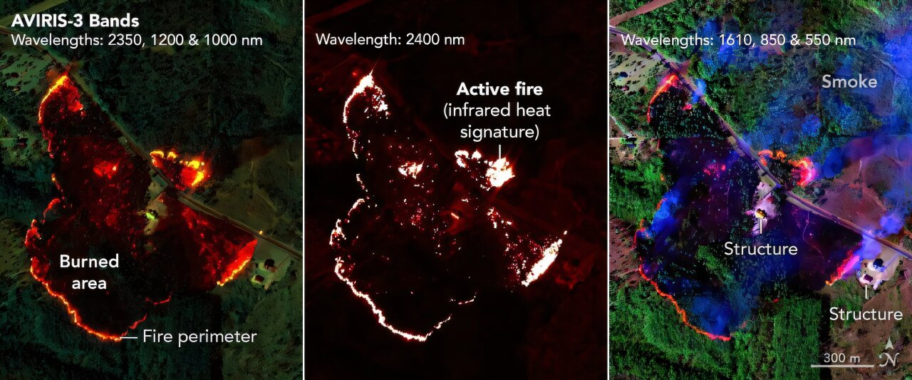
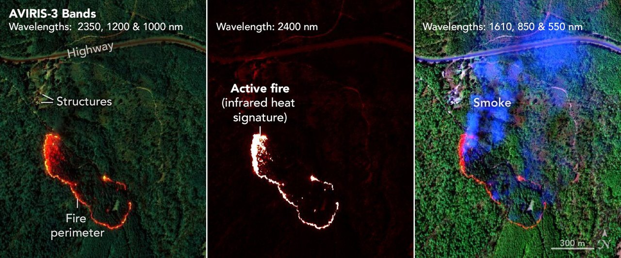
In the flights conducted during March, scientists generated three kinds of maps. The first type, known as the Fire Quicklook, merges brightness readings from three different infrared light wavelengths—none visible to humans—to gauge the fire’s strength. On these Fire Quicklook charts, orange and red regions represent less severe burn zones, whereas yellow highlights spots with fiercest flames. Areas previously affected by fires appear as dark reddish-brown patches.
A different kind of map, known as the Fire 2400 nm Quicklook, focuses exclusively on infrared radiation with a wavelength of 2,400 nanometers. These visuals are especially helpful for identifying hotspots and delineating fire boundaries, appearing vividly bright against a backdrop of red.
A third kind of map, known as Quicklook, displays burnt regions and smoke.
The Fire 2400 nm Quicklook was the “crowd pleaser” according to Ethan Barrett, a fire analyst with the Forest Protection Division at the Alabama Forestry Commission. This thermal imaging tool allowed firefighting teams to identify the shape and location of wildfires from above, which aided them in deciding where to deploy bulldozers to halt further expansion.
In addition, the team from FireSense examined the AVIRIS-3 images to generate digital outlines of the fire zones. This offered first responders rapid and detailed insights into the conditions at hand.
This occurred during the Castleberry Fire. With a distinct understanding of which areas were experiencing the highest intensity, firefighters were able to concentrate their efforts on the northeastern perimeter where they had the greatest chance to have an impact.
Two days following the detection of hotspots at the Castleberry Fire, the sensor identified another blaze approximately 4 miles (2.5 kilometers) southwest of Perdido, Alabama. While forest service personnel were striving to stop the flames from spreading towards six adjacent structures, they observed that the primary hotspot within this new fire was located inside the containment area. Armed with this information, authorities opted to reallocate certain assets toward different blazes situated roughly 25 miles (40 kilometers) away near Mount Vernon, Alabama.
In an effort to control one of the Mount Vernon fires, teams utilized AVIRIS-3 mapping technology to identify suitable locations for setting up firebreaks past the northwestern perimeter of the flames. As a result, they managed to contain the inferno at a distance of approximately 100 feet (30 meters) from four structures.
Flames spread much quicker than a bulldozer, which means we must attempt to navigate our way around it before it engulfs us. These maps help identify the areas with intense heat,” Barrett explained. “Once I step out of the vehicle, I can assess the boundary and declare, ‘This is where the edge lies.’ This gives me an enormous advantage.
AVIRIS and the Firesense Airborne Campaign are components of NASA’s efforts to utilize their expertise in fighting wildfires through various technological solutions, such as those employing aerial platforms. Additionally, the organization has lately showcased a prototype developed under its Advanced Capabilities for Emergency Response Operations initiative. This new system aims to ensure effective airspace control for both unmanned vehicles like drones and manned aircraft involved in operations over wildfire zones.
Provided by NASA
This tale was initially released on
Viral Buzz News
. Subscribe to our
newsletter
For the most recent science and technology news updates.